Showing posts with label hiking. Show all posts
Showing posts with label hiking. Show all posts
Friday, September 9, 2011
More images from Colorado and Utah
Of course we took loads of images during our latest trip. In case you would like to see more from our latest adventures in Colorado and Utah click here.

The Narrows

The last day before heading back to Phoenix and reality again we hiked The Narrows in Zion National Park. This is a narrow canyon through which the Virgin River runs. It is so narrow that you have to hike in the river most of the time. Since this was going to be our last hiking day we did not care about getting our boots wet and the heat made it feel very tempting to hike in the cool river.
To be on the safe side we rented poles at an outdoor store that would help us keep the balance in the stream. Many hiked without but I was happy to have one so I didn't have to swim unless it was necessary. In fact we did not have to swim at all, at the deepest place the water reached up to my chest. Unfortunately this was after about 10 min so you had to get wet from the very beginning but then it was mostly knee deep.

It was a different and fun hike in the water but after a couple of hours we decided to turn back because we were getting a bit cold. Luckily at this time the sun was high enough to shine down into the canyon which helped us keep warm. I am not sure I would attempt this hike any other time of the year. In that case you have to rent a dry suite to keep warm.
Wednesday, September 7, 2011
Zion National Park
 View over Zion National Park from Angel's Landing
As we drove into Zion National Park we realized that we were getting back to desert temperatures. It was suddenly very hot again and it was hard to sleep at night. You can't really have the engine running all night for air condition... Bryce had been warm during the day but fairly nice due to the elevation.
The heat was a factor when we chose the hikes to do here. We decided on Angel's Landing as early in the morning as possible and Lost Canyon which was a short hike in the shade most of the day. It turned out to be a good decision and we had time to get out in the afternoon and have coffee in an air conditioned café, a swim in the cold river and a beer before cooking dinner.
 You have to hike this narrow ridge to reach Angel's Landing
 Fun stuff!
Tuesday, September 6, 2011
Overnight hike in Bryce Canyon
 Bryce Canyon
In Bryce Canyon we decided to do an overnight hike. We caught a lift with the tour bus to the south end of the park and hiked back to the more popular area closer to the entrance of the park. As we came to our final stop the bus driver told the other passengers, mostly overweight older americans, that he wanted to say goodbye to the two hikers and wish us a nice hike back. As we were leaving the bus the other passengers expressed their admiration and best wishes, it was obvious it is not very common to do a longer hike in this park.
 At the starting point.
Before heading out you need to get a backcountry permit and reserve a spot at one of the few campgrounds along the way. We chose a camp about half ways after we added a loop of about 14 km in the south part of the park. Afterwards we realized that the loop had not been necessary to do since it was mainly in the forest without any view. It mainly just added time and effort. What we did see though were a lot of cute horned lizards, actually 19 of them. We had seen one in Arizona earlier this year and got the feeling they are rare to see but here they were everywhere.
 Horned lizard
As we got our permit they also gave us a bear vault. This is a box with a lid that is bear proof in case one happened to find us and decide to try and steal our food. In the box we had to keep all food and scented items, like tooth paste. We also got very clear instructions on how and were to cook, sleep and go to the bathroom. We believe we followed the directions which should ensure that the park is kept clean and bears away from the tourists. They have had to put down two bears because they were stalking tourists looking for food. This is what happens when people leave food at campsites. Luckily we were not stalked, we only saw the foot prints of a mountain lion in the morning. We were ok with that.
 Cooking dinner. Bear vault to the right.
Most of the hike was down in the valley underneath the rim which Bryce Canyon is so famous for. The very first part going down from Rainbow Point and the very last part coming up to Bryce Point were the nicest ones. On the way the trail went up and down a number of hills which turned out to be quite strenuous. The hike was in total about 50 km so we did about 25 km per day which is probably about what I can take with a heavy backpack and elevation change. We made it though and looked forward to shorter day hikes for the rest of the holiday.
 Coming down from Rainbow point
Thursday, August 25, 2011
Needles - an unexpected adventure
After some breakfast in our favourite café in Moab we drove south towards Needles. The Needles is a part of Canyonlands National Park and since we already had a backcountry permit for this park we thought we should drive in and have a look.
This is what we did NOT read before driving happily along and now we also understand why the park rangers wished us good luck...

So, we did not know that we were about to drive one of the hardest trail in the state although it was written on our map, on the flyer we got at the ranger station and on the big board as you start the drive. We simply did not read it... Maybe sometimes it is good not to know everything.
We just wanted to drive in, hike a bit and camp somewhere in the park and then leave the next morning. It turned out being quite a drive with one of us most of the time in front of the car spotting the best way to go. We knew that the car was capable of a lot but we did not really want to try it out because we did not want to break it. Now we know more.


 We made it through without any damages to the car, but next time we will probably hike into the area and leave the poor car safe on the paved parking lot. Once we reached our camp we went for a hike and it was all worth it because this is what we saw.


The fact that the hike was longer than we expected (our mistake again), that we had to hike the last hour or so in the dark (luckily we were clever enough to bring head lamps), that we lost the trail for a short while and were hungry and tired is something we don't really remember anymore. Somehow it is almost always worth it.
This is what we did NOT read before driving happily along and now we also understand why the park rangers wished us good luck...

So, we did not know that we were about to drive one of the hardest trail in the state although it was written on our map, on the flyer we got at the ranger station and on the big board as you start the drive. We simply did not read it... Maybe sometimes it is good not to know everything.
We just wanted to drive in, hike a bit and camp somewhere in the park and then leave the next morning. It turned out being quite a drive with one of us most of the time in front of the car spotting the best way to go. We knew that the car was capable of a lot but we did not really want to try it out because we did not want to break it. Now we know more.


 We made it through without any damages to the car, but next time we will probably hike into the area and leave the poor car safe on the paved parking lot. Once we reached our camp we went for a hike and it was all worth it because this is what we saw.


The fact that the hike was longer than we expected (our mistake again), that we had to hike the last hour or so in the dark (luckily we were clever enough to bring head lamps), that we lost the trail for a short while and were hungry and tired is something we don't really remember anymore. Somehow it is almost always worth it.
Arches National Park
After a well deserved shower and over night stay at a camp ground we were ready to take on Arches National Park. We started with some coffee at a café in Moab before heading out to the park which is very close to town.
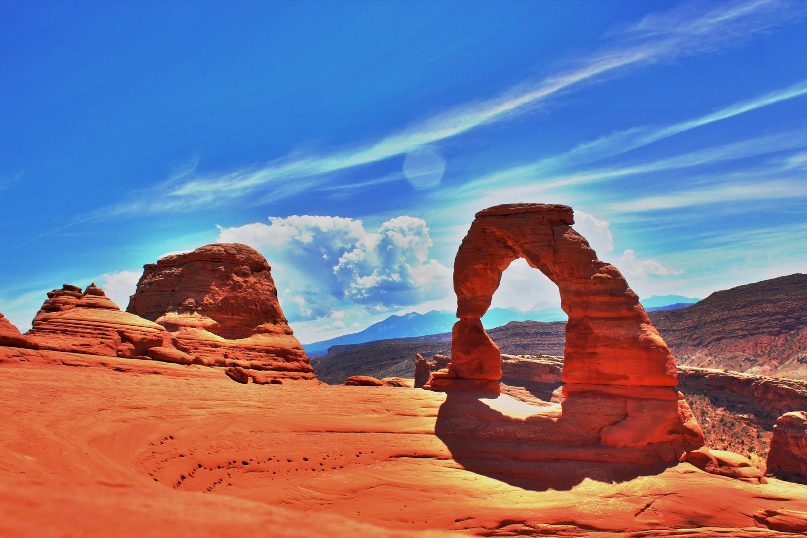
The first target was Delicate Arch which the park is probably most known for. It is a maybe 20-30 min hike to get to the arch, which is not too much but the heat makes it fairly tiring. We had checked the weather which said possible rain and thunderstorms in the afternoon so we did this hike first although the light for photos is better in the afternoon. With some tricks we still got a cool picture.

Next stop was Devils Garden which was a bit longer hike but featured some very nice views, arches and some rock hopping. The trail was a lot more fun here but we ended up in the middle of a sand storm so we had to rush back after half the trail. We met many tourists on their way into the area as we were coming out. Many with their SLR cameras in their hands trying to take pictures in the sand storm. The wind was very strong and you could feel the sand between your teeth. I expect some of them having to bring them in for cleaning afterwards. We had packed ours safely in the camera bag.


The first target was Delicate Arch which the park is probably most known for. It is a maybe 20-30 min hike to get to the arch, which is not too much but the heat makes it fairly tiring. We had checked the weather which said possible rain and thunderstorms in the afternoon so we did this hike first although the light for photos is better in the afternoon. With some tricks we still got a cool picture.
Next stop was Devils Garden which was a bit longer hike but featured some very nice views, arches and some rock hopping. The trail was a lot more fun here but we ended up in the middle of a sand storm so we had to rush back after half the trail. We met many tourists on their way into the area as we were coming out. Many with their SLR cameras in their hands trying to take pictures in the sand storm. The wind was very strong and you could feel the sand between your teeth. I expect some of them having to bring them in for cleaning afterwards. We had packed ours safely in the camera bag.


Friday, August 12, 2011
We did it!

Ten 14ers and one 13er in 10 days. Out of those ten days two were resting days which means three of eight hiking days we did two peaks. Right now I feel extremely good but I don't think I could have done many more without some more rest at this point. My body wants to do something else.
The last five 14ers were Mt Harvard and Mt Columbia (one day), Mt Yale, La Plata and Mt Elbert. Mt Elbert is the highest of the 14ers and the highest peak in Colorado and the Rocky Mountains. It was ironically the easiest one and had the biggest crowd on top. There were hikers on all peaks we visited but usually 5-10 others while on Mt Elbert there were probably about 20 and we met many still on their way up as we hiked down.
 At Mt Harvard early in the morning we saw two mountains goats. This one was a bit scruffy looking but very cute.
 Driving through an aspen forest to reach Mt Elbert trailhead.
We were surprised as to how few foreigners we met in the mountains. On ten peaks we only met three foreigners, two from the Czech Republic and one from Canada. All of these though live in the States at the moment as do we. I guess that we can now say that the international tourists does not make it to these wonderful areas. They are missing out on something! Apparently the tourists go to Rocky Mountain National Park and Mt Evans where you can drive all the way to the top of the mountain. It seems a lot of people from the cities in Colorado do weekend trips up to the mountains to go hiking, biking, rafting and 4 wheel driving. There was a very impressive traffic jam coming back to Denver on Sunday afternoon as we were leaving to go to Utah. Luckily we were going in the right direction.
 Leaving the mountains for other adventures.
Monday, August 8, 2011
Five 14ers done, five to go
 Uncompaghre, 14321 ft or 4365 m
Now we have done five 14ers and one 13er. We threw in the 13er just because it was named Matterhorn. This Matterhorn is much easier to climb than the Matterhorn in Switzerland. The peaks we have climbed so far are Handies, Redcloud, Sunshine, Wetterhorn, Matterhorn and Uncompaghre. Redcloud and Sunshine we did in one day as well as Wetterhorn and Matterhorn. The two last mentioned peaks were a bit different than the others because you had to do a bit of climbing to reach the top. It was quite fun, easy climbing more scrambling really.
 On the top of Matterhorn.
 Enjoying the view on Uncompagre.
We had one days rest after 3 peaks and now another lazy day before we are aiming to do five peaks in four days. We do not know if we will make it but we will try. The reason is that in four days the weather forecast says there might be thunderstorms and we would like to avoid them if possible.
 There are lots of marmots around these mountains, we see them everywhere. This one we found quite close to the top of Uncompaghre. Apart from marmots we see chipmunks, deer and elk. They claim bears are around but we have not seen one so far and honestly I do not have to...
Friday, August 5, 2011
14ers in Colorado

About 20 years now I have dreamt about going to Colorado and climb 14ers (mountains higher than 14000 feet or 4250 meters). In 1999 I bought the Lonely Planet Rocky Mountains and started to read in about the area. However I never made it there until now... The picture shows the view from Handies Peak towards Uncompaghre, Wetterhorn and Matterhorn.
After having spent the summer in Arizona with temperatures above 40 degrees Celsius it was nice to get up higher and get some fresh air. Also we all of a sudden had to experience rain again which we have had very little of although it is monsoon season in Arizona.
Although the mountains here are very high it looks like the Alps on 2000 meters. The tree line here is at around 3000 meters while in the Alps it is around 1800 meters. So even if you are much higher here you can not really tell except it is much harder to hike due to the elevation. We thought we were in good shape on Arizona heights but here it feels like I have not done any exercise in a long time.

On the top of Sunshine.
So far we have climbed three 14ers in two days and are now having a days rest. We are after all on holidays and do not want to strain our bodies too much the first few days. Tomorrow the next peak awaits.

On the way up on Handies Peak you walk through this lovely valley with loads and loads of flowers. Very beautiful.
Wednesday, February 9, 2011
Our first roadtrip in the States - Joshua Tree National Park
Joshua Tree National Park was exactly the change of scenery that we needed. From fancy bars, restaurants and huge yachts to desert, rock and mountains. In two days we did three hikes. All of them were easy, the mountains here are not very high and the trails are easy to walk.
We drove into the park through the southern entrance at Cottonwood Visitor Center. From here we hiked to Lost Palms Oasis which was a very nice hike that featured some cool parts through small canyons, dry river beds and at the end an oasis with palm trees. To reach the oasis you had to walk down a fairly steep canyon. The view was of course much better from the top of the ridge where we stopped for some snacks.
 Walking along a ridge to Lost Palms Oasis.
 The palm trees at Lost Palms Oasis.
 On the way back to the parking lot we climbed Mastodon Peak which was a quite airy peak with lots of boulders you could climb around on. In the background you can see the Salton Sea.
Close to Keys View we hiked the Lost Horse Mine Trail. This is an easy hike which takes you past an old gold mine which is fairly intact. The mine was build in the late 18-hundreds and was in use for almost 4 decades. In total it produced about 280 kg of gold and 450 kg of silver. After visiting the mine we climbed a couple of peaks along the trail which were not really on the map. Just for the fun of it. It was very windy and cold also here so we did not stay for long. At the end the trail seemed to be never ending going through the valleys back to the parking lot. When we came back we had been away for 2-3 hours so it was actually shorter than it seemed.
 Joshua Trees.
After a sandwich lunch at Cap Rock (were we found some bolted climbing routes which made us miss our climbing gear) we hiked Ryan Mountain. It was a quite easy hike which did not take more than 30-40 min. This peak is in the center of the western part of the park and from here you have a great view of the whole Joshua Tree National Park.
 The view towards north west from Ryan Mountain. On many of the small rocks you can see in the valley there are climbing routes. So next time we will be bringing climbing gear.
 On a mini hike in Hidden Valley just before the sun went down. The light was fantastic this time of day. It is at these moments I seriously consider buying an SLR camera.
Joshua Tree is a great place if you like hiking, desert and large boulders. The rock formations you find here are amazing and there are many places to play around among the boulders.
 Having fun at White Tank campground.
We found it magical and will be going back. We highly recommend a visit if you have not been here.
We drove into the park through the southern entrance at Cottonwood Visitor Center. From here we hiked to Lost Palms Oasis which was a very nice hike that featured some cool parts through small canyons, dry river beds and at the end an oasis with palm trees. To reach the oasis you had to walk down a fairly steep canyon. The view was of course much better from the top of the ridge where we stopped for some snacks.
 Walking along a ridge to Lost Palms Oasis.
 The palm trees at Lost Palms Oasis.
 On the way back to the parking lot we climbed Mastodon Peak which was a quite airy peak with lots of boulders you could climb around on. In the background you can see the Salton Sea.
The second day we picked up some breakfast at the local supermarket and drove up to Keys View. The plan was to sit and watch the view while eating. We ended up eating in the car and then went out for 5 min to take some photos. The reason being that it was extremly windy and cold outside. From Keys View you could look towards the south and Palm Springs which is outside the National Park.
 At Keys View.
 At Keys View.
 Joshua Trees.
After a sandwich lunch at Cap Rock (were we found some bolted climbing routes which made us miss our climbing gear) we hiked Ryan Mountain. It was a quite easy hike which did not take more than 30-40 min. This peak is in the center of the western part of the park and from here you have a great view of the whole Joshua Tree National Park.
 The view towards north west from Ryan Mountain. On many of the small rocks you can see in the valley there are climbing routes. So next time we will be bringing climbing gear.
  On a mini hike in Hidden Valley just before the sun went down. The light was fantastic this time of day. It is at these moments I seriously consider buying an SLR camera.
Joshua Tree is a great place if you like hiking, desert and large boulders. The rock formations you find here are amazing and there are many places to play around among the boulders.
 Having fun at White Tank campground.
We found it magical and will be going back. We highly recommend a visit if you have not been here.
Friday, November 12, 2010
Last chance
Winter is definately around the corner. In Sweden we have already seen the first snow. This week we had a snow storm and although it is a few days ago there are still traces of it on the ground. Lucky me then who could go down to Switzerland last weekend and enjoy some warmer weather.
Since the weather was nice we took the opportunity to go on maybe the last hike of the season. Since it is cold and snowy on high altitude we chose Bürgenstock this day. This mountain is only about 1100 meters but beautifully situated at the lake Vierwaldstätter See and famous for its views. This particular mountain does not have a gondola but actually a lift that can take you up the last few hundred meters. This day however it was already closed for the season, not even the café was open. So we did not get our standard beer on the top of the mountain but had to be content with what we had brought along.
 On the way we had some serious Sound of Music moments. Like here when we crossed a meadow with this spectacular view.
 As we came around the mountain we got this great view of the lake and Lucerne. This side of the mountain is very steep and the footpath is not intended for people that have issues with heights. At some places they have even made tunnels through the rocks. Very nice hike that can be made a little longer if you choose to leave the car close to Stansstad and take the way over Bürgenbergwald.
Since the weather was nice we took the opportunity to go on maybe the last hike of the season. Since it is cold and snowy on high altitude we chose Bürgenstock this day. This mountain is only about 1100 meters but beautifully situated at the lake Vierwaldstätter See and famous for its views. This particular mountain does not have a gondola but actually a lift that can take you up the last few hundred meters. This day however it was already closed for the season, not even the café was open. So we did not get our standard beer on the top of the mountain but had to be content with what we had brought along.
 On the way we had some serious Sound of Music moments. Like here when we crossed a meadow with this spectacular view.
 As we came around the mountain we got this great view of the lake and Lucerne. This side of the mountain is very steep and the footpath is not intended for people that have issues with heights. At some places they have even made tunnels through the rocks. Very nice hike that can be made a little longer if you choose to leave the car close to Stansstad and take the way over Bürgenbergwald.
Monday, October 11, 2010
Autumn hike in Switzerland
This past Saturday we did the Four Lake Hike (Vier Seen Wanderung) between Melchsee Frutt and Engelberg. The SBB (Swiss Railway) has a special ticket for this hike which includes train, bus and cable cars on both ends which makes it quite worth its price. Otherwise the trains and cable cars in Switzerland are very pricey.

In the valleys the fog was thick the entire day but above 1500 meters or so the sky was blue and the sun was shining. The perfect day for an autumn hike on high altitude.

Hiking along the rigde from Bonistock towards Tannensee. Below us on the right side there is a climbing wall with more than 130 routes in all ranges. Actually we came back on Sunday to do some climbing there.

Tannensee.

Having lunch at Engstlensee. This was the lowest point on the hike and after this we had to climb about 400 meters to Jochpass and then down again to reach the cable car on the other side. On Jochpass we did get a well deserved beer before we walked down the last bit. The hike took about 4 hours. With breaks we spent about 6 hours on the track.
All pictures were taken by Michael Wicki who brought us on this hike. Thanks for a great day, Quicky!
Subscribe to:
Posts (Atom)